Save this image free of charge
in 800 pixels for layout use
(right click, Save as...)
|
|
Ref : T01980
Theme :
Looking at Earth - Plains - Plateaus - Valleys (487 images)
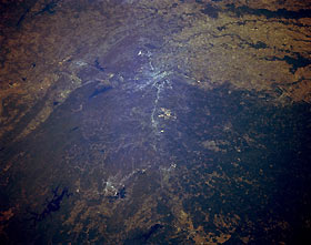
Title : Little Rock, Arkansas, U.S.A. October 1994
Caption :
This synoptic, northeast-looking photograph shows the diverse landscape of central Arkansas. Numerous irregularly shaped, dark reservoirs are identifiable—viewing clockwise from De Gray Lake (bottom center) are Lake Hamilton; serpentine Ouachita Lake; elongated Maumelle Lake; Lake Conway; and part of Greers Ferry Lake. The Arkansas River flows northwest to southeast through the heart of Little Rock (slightly above center), through which runs Interstate Highway 30. The lighter terrain (upper right quadrant) is part of the old Mississippi River floodplain that is used extensively for agriculture. Pine Bluff (near right center) lies southeast of Little Rock.
|
|

